Report on Opportunities From Use of Geospatial Technologies in Water Sector Released by DG, NMCG
Report on Opportunities From Use of Geospatial Technologies in Water Sector Released by DG, NMCG
20 JUL 2021 8:54PM by PIB Delhi
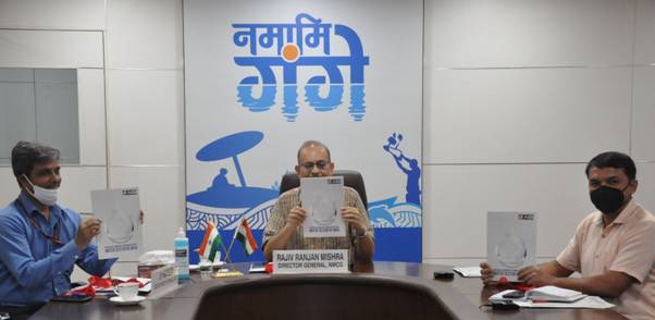
Director General, National Mission for Clean Ganga, Shri Rajiv Ranjan Mishra today released a detailed report on the opportunities in the Water sector that can benefit from the use of Geospatial technologiesthrough an online event. Outlining key water sector programmes and projects in the country, the report provides an overview of how each of these programmes is currently using geospatial technologies, and how to improve technology adoption in the future. Over 60 water and geospatial technology experts from across the country provided inputs for this report.


As per the reporta plethora of Geospatial and Digital technologies, like Satellite based Remote Sensing, Surveying and Mapping, GPS based equipment and sensors, GIS and Spatial Analytics, Artificial Intelligence, Big Data Analytics, Internet of Things, 5G, Robotics and Digital Twin, can be effectively used to combat the water crisis.
Given the population density and requirement of water for agriculture, India is heavily dependent on groundwater and is one of the worst hit countries as far as the water crisis is concerned. Government is making a lot of efforts to tackle this situation. To support the Government, combat this pervasive challenge and to ensure better water management in the country, the Association of Geospatial Industries – a geospatial technology industry body, has prepared this report titled, “Potential of Geospatial Technologies for the Water Sector in India”.
Shri D.P. Mathuria, Executive Director (Technical), NMCG and Shri Peeyush Gupta, Real Time Information Specialist, NMCG were also present. Shri Mishra expressed happiness to see this initiative and said it is critical for us to use the latest and best digital and spatial technologies to make data-based informed decisions. He explained the various applications of the technologies in the Namami Gange Mission for mapping of different attributes of the Ganga basin. Various other missions such as Jal Jeevan Mission, Atal BhujalYojna, also have set up projects using these technologies. Mr Mishra emphasised on the need for collaborating with stakeholders in the entire ecosystem such as Geospatial organizations, academics, Policy makers, funding agencies etc.
Several recommendations have been given in the report to strengthen the adoption of technology to realise better outcomes. As a quick resource meant for the professionals in the water domain, as well as technology enthusiasts, the report has also listed several case studies highlighting the use of geospatial technologies in different contexts related to water problems. It has also shared a list of those openly available.
Click here to see full report.
*****
AS
(Release ID: 1737365)
Visitor Counter : 19