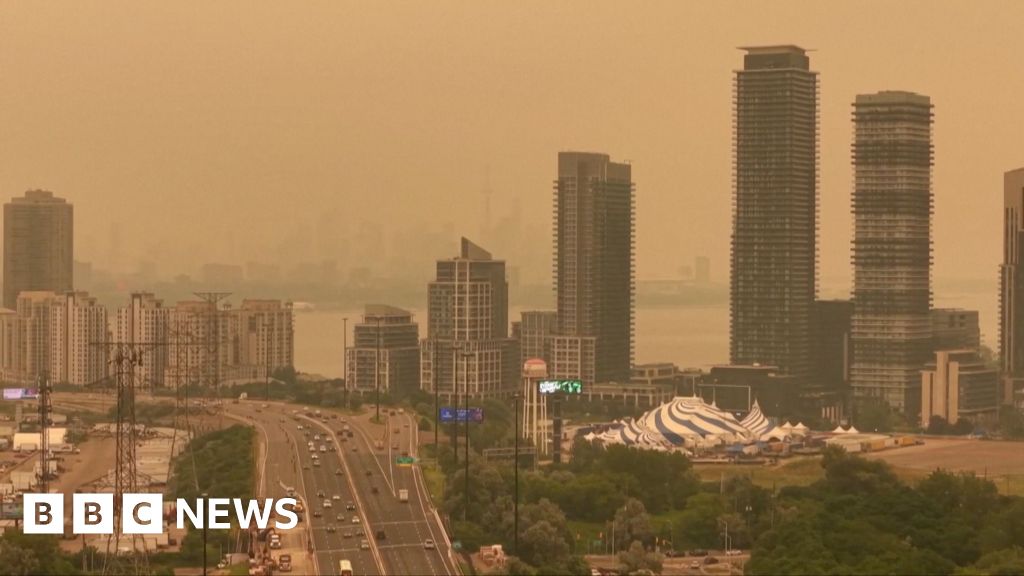
Canada wildfires produced an eerie orange haze across Ontario and into parts of the northern United States, as dense smoke from multiple blazes filtered sunlight and changed daytime colour. Video and photos of the sky were reported by BBC News – Top Stories; the broadcaster’s video of the scene is available near the top of this report for context: BBC News video of orange haze.
Orange haze visible across Ontario and the northern US
Across Ontario, observers described a deep orange tint to daylight and an altered quality of light that persisted for hours. Similar reports came from border areas in neighbouring US states where people noticed reduced clarity and unusual colouring of the sky. Local photographs and eyewitness video—compiled in BBC News coverage—show the haze over both urban skylines and rural landscapes.
The visual effect is most pronounced where smoke concentration is highest; distance from individual fires, prevailing winds and local weather conditions created wide variations in visibility and colour even within a single city.
Canada wildfires: scale and official count
As of 16 July 2026 the Canadian Interagency Forest Fire Centre (CIFFC) reported 838 wildfires active nationwide. That figure is time-sensitive and may change as new updates are published by CIFFC and provincial fire services. The CIFFC’s national summary is the official aggregation of reports from provincial and territorial agencies.
Large numbers of active fires increase the likelihood of long-distance smoke transport and episodic regional haze as plumes from several sources merge in the atmosphere.
How smoke traveled across the border
Smoke from wildfires can rise tens to hundreds of metres into the atmosphere and be carried long distances by prevailing winds. Fine particles and aerosols scatter sunlight differently than clear air; when particle concentrations are high they preferentially scatter shorter (blue) wavelengths, letting longer (red and orange) wavelengths dominate, which produces the orange tint reported by witnesses.
Wind direction, wind speed, the height of rising smoke columns and atmospheric stability all determine where and how concentrated smoke plumes become at ground level. Upper-level winds can carry smoke hundreds of kilometres, while local temperature inversions can trap smoke near the surface and increase haze for communities downwind.
What residents should know now
Visibility and air quality can change rapidly. Drivers experiencing reduced visibility should slow down, use low-beam headlights and keep extra distance from other vehicles. If smoke reduces visibility severely, pull over safely and wait until conditions improve.
Smoke contains fine particulate matter (PM2.5) that can irritate the eyes, nose and throat and aggravate respiratory and cardiovascular conditions. People with asthma or chronic heart or lung disease, older adults and young children are generally more vulnerable to smoke exposure. Public health agencies advise limiting strenuous outdoor activity during smoky periods and using cleaner indoor air practices where possible.
Practical steps to reduce exposure:
- Monitor local air quality and public health advisories from municipal, provincial or state agencies and from recognised air-quality tools such as government-run indices.
- Keep windows and doors closed when smoke is heavy and run air conditioning on recirculate if available and appropriate for your unit.
- Use a properly fitted N95/FFP2 respirator if you must be outdoors in smoky conditions; a cloth mask or surgical mask does not reliably filter fine particles.
- Consider an indoor HEPA air purifier in frequently used rooms to reduce indoor particle levels.
- Protect pets: bring them indoors, limit their outdoor exercise and watch for signs of respiratory distress.
By the numbers
- Active wildfires in Canada: 838 (Canadian Interagency Forest Fire Centre national update, 16 July 2026)
- Regions reporting visible haze: Ontario and parts of the northern US (reported in BBC News coverage)
- Main observable effect: orange-tinted daylight and reduced visibility where smoke was concentrated
Short outlook and precautions
Forecasts for smoke movement depend on weather changes. A shift in wind direction or a change in frontal patterns can move plumes into new regions with little notice. Residents in affected or downwind areas should expect variable air quality over the coming days and prepare accordingly.
Local officials may issue air-quality advisories, evacuation orders or other guidance for specific communities. Follow instructions from municipal or provincial authorities, keep emergency supplies accessible, and plan for disruptions to outdoor events or travel if smoke intensifies.
For people with significant respiratory or cardiac conditions, contact your healthcare provider for tailored advice. Public health units and weather services can provide real-time air-quality readings and forecasts to help decide when it is safest to be outdoors.
The featured photograph associated with this story shows smoke and haze over a city skyline; accompanying aerial imagery highlights large smoke plumes sweeping across forested areas and the scale of visible haze in some regions.
Source attribution: Reporting compiled from BBC News – Top Stories coverage of the orange haze (video and eyewitness footage) and the Canadian Interagency Forest Fire Centre national wildfire summary (CIFFC). For the CIFFC national update and the latest active-fire count, see the Canadian Interagency Forest Fire Centre’s official site. For the BBC video and coverage referenced above, see BBC News – Top Stories.