Super typhoon Bavi is bearing down on Guam and has prompted evacuation orders as it strengthens, with forecasts calling for winds in excess of 160mph and waves nearing 11m at the expected landfall on Monday. The storm represents a direct threat to life, homes and coastal infrastructure. Residents and visitors should follow evacuation notices, secure property now and monitor official updates.
Immediate threat from super typhoon Bavi
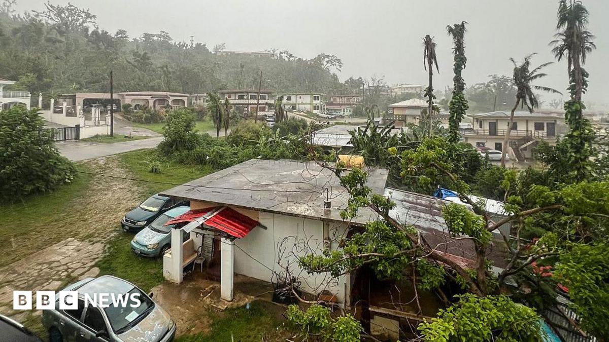
The system identified as super typhoon Bavi has shown signs of rapid intensification as it approaches the Mariana Islands. Forecasts by BBC and meteorological agencies project sustained winds in excess of 160mph and storm-driven waves approaching nearly 11m in height at the coast by the time of landfall on Monday. These forecasts remain subject to revision as the storm’s track and strength evolve.
The combination of extreme winds, torrential rain and very large waves creates a multi-hazard situation: destructive wind damage, life-threatening storm surge, and hazardous marine conditions. The timing of the most severe weather is currently centred on Monday, but peak impacts could begin in the 24–48 hours beforehand as outer bands arrive.
Evacuations and local response in Guam
Authorities in Guam have begun implementing evacuation plans for the most vulnerable coastal and low-lying communities. BBC News reports that evacuations are under way and local emergency management teams are mobilising shelters, search-and-rescue resources and logistics to support displaced residents.
Local government agencies are prioritising people in officially designated evacuation zones — typically coastal villages, flood-prone inland areas and communities threatened by storm surge — and are advising those residents to move immediately to designated shelters or inland safe areas. Exact maps and shelter locations are being updated by Guam Homeland Security/Office of Civil Defense; check the official site for realtime guidance and shelter lists: ghs.guam.gov.
Emergency teams are also coordinating with utilities, ports and local authorities to pre-position personnel and supplies. Residents are urged to treat evacuation orders as serious: these measures are intended to reduce the risk to life when extreme winds and surge arrive.
Forecast impacts and risks
Meteorological agencies warn that winds above 160mph are associated with catastrophic structural damage, prolonged power outages and widespread downed trees and lines. According to forecasts cited by BBC, waves approaching nearly 11m can overtop sea walls, inundate coastal roads, destroy small piers and place vessels and marinas at grave risk.
Heavy, sustained rainfall with this storm increases the likelihood of flash flooding and landslides in vulnerable terrain, extending risk inland beyond immediate coastal zones. Combined hazards mean that staying away from the shoreline and moving to officially designated safe locations is essential for survival.
What residents and visitors should do
If you are in an evacuation zone: evacuate immediately to the nearest official shelter or an inland location away from coastal surge zones. Do not delay to collect non-essential items. Evacuation orders are issued to protect life and should be followed even if you believe your home is structurally sound.
If you are not in an evacuation zone but remain on Guam: finalise preparations now. Secure loose outdoor items, move vehicles to higher ground if possible, board or shutter windows, and bring essential supplies together. Prepare an emergency kit with at least 72 hours of water and food, required medications, important documents, torch/flashlight, extra batteries and a battery-powered or hand-crank radio.
Avoid travel during heavy rain and high winds; do not attempt to drive through flooded roads. Keep clear of beaches, piers and sea cliffs while conditions deteriorate. Maritime activities should be suspended immediately and small craft should seek safe harbour well before rough seas arrive.
Monitor official channels for shelter capacity, opening times and any changes to evacuation areas. The Guam Homeland Security site (ghs.guam.gov) will post official advisories, shelter lists and contact information. If you require assistance and cannot reach local offices, follow instructions from shelter staff and first responders on site.
What comes next and timeline
Forecast centres and local emergency management will continue to issue advisories through the weekend and into Monday. Expect frequent updates to track, intensity and recommended protective actions as new data arrives. BBC’s reporting and meteorological agencies are cited for current wind and wave forecasts; readers should treat those figures as subject to change.
Key short timeline:
- Now: Evacuation orders are being implemented for coastal and flood-prone areas. Complete preparations and evacuate immediately if ordered.
- Next 24–48 hours: Conditions will deteriorate as the storm’s outer bands arrive — heavy rain, dangerous surf and strengthening winds are likely.
- Monday: Current forecast window for landfall; peak winds and largest waves are expected around this time, though timing and impacts may shift with new advisories.
Continue to monitor official announcements and be prepared for extended disruptions to power, communications and transport. If you are sheltering, follow directions from shelter personnel and safety officials until they declare it safe to leave.
Source attribution
This report uses forecasting and reporting from BBC News and meteorological agencies. For official instructions, shelter locations and emergency contacts, consult Guam Homeland Security/Office of Civil Defense at ghs.guam.gov and follow local authorities’ guidance. For the BBC’s coverage referenced in this article, see the BBC report on Guam evacuations linked below.
Source: BBC News – Evacuations in Guam as super typhoon Bavi approaches