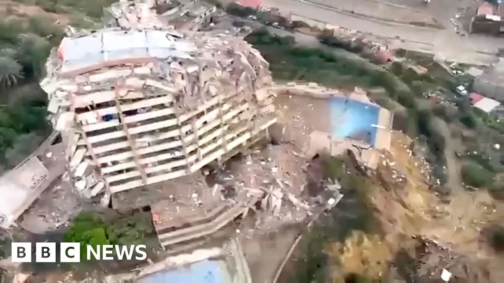
The La Guaira earthquakes were followed by aerial footage showing collapsed multi-storey buildings and rubble-strewn streets in the coastal city. Short overhead clips shared by BBC News provide an early look at structural damage across neighbourhoods near the port and shoreline.
The footage, released shortly after the events, surveys damaged blocks, blocked roads and concentrated debris in low-lying areas. Because the material is from aerial surveys, it offers a broad visual assessment but does not replace on-the-ground inspections by emergency teams.
La Guaira earthquakes: extent of building damage in La Guaira
Aerial shots show multiple multi-storey buildings either partially collapsed or reduced to rubble. Concrete frames and shattered facades are visible in densely built residential blocks close to the coast, and debris appears to have blocked several streets, hindering movement.
The most visible damage is concentrated in older, low-lying neighbourhoods where buildings sit close together. In the footage, some high-rise residential blocks show major structural failure on upper floors, while adjacent properties show severe façade and roof damage.
These aerial images illustrate the immediate visual impact: collapsed walls, fallen concrete and fractured road surfaces. However, they cannot confirm the structural integrity of every building, the safety of utilities such as water and power, or whether key public services remain functional without inspection by engineers and emergency personnel.
What is known about the quakes
Early reporting from BBC News indicates that two major earthquakes struck on Wednesday. The initial video report did not include technical seismic readings in the footage itself, and magnitude, depth and precise epicentre coordinates have not been confirmed in that material.
Seismological agencies and national civil protection bodies customarily publish detailed technical readings and formal damage assessments following such events. Those organisations are expected to release magnitude, depth and epicentre data as they verify instrument records and field reports. Casualty and injury figures remain unconfirmed at this stage and any early numbers should be treated as preliminary until official tallies are released.
Why this matters for coastal Venezuela
La Guaira is a significant port and coastal municipality that supports commerce, transport and services for Caracas and surrounding regions. Extensive damage in La Guaira can disrupt supply routes, port operations and daily access to essential services for large populations in coastal communities.
Coastal areas have additional vulnerabilities after strong ground shaking: landslides in steep zones, coastal erosion or instability, and damage to ports and piers. Utility outages and blocked roads can complicate urgent search-and-rescue operations, medical response and delivery of humanitarian assistance.
Collapsed multi-storey residential buildings also drive immediate needs for shelter, medical care and rapid search operations for anyone who may be trapped under rubble. Assessing which buildings remain habitable and identifying priority routes for emergency vehicles will be a near-term focus for responders.
What comes next and where to follow updates
In the immediate hours after such earthquakes, emergency responders typically prioritise search and rescue, stabilising damaged structures, medical triage and clearing main roads to allow relief access. Municipal services and national disaster agencies will coordinate assessments to determine urgent needs, including shelter, water, medical supplies and power restoration.
Humanitarian groups and municipal officials need verified data on the number of damaged homes and the condition of hospitals and utilities before scaling up larger relief operations. Seismological institutes and civil-protection agencies are expected to publish measured seismic data and formal damage assessments that will guide the response.
Readers seeking official, confirmed updates should monitor communications from Venezuela’s civil protection authorities and national seismological bodies, alongside established news organisations. BBC News – Top Stories is carrying the early footage and reporting; for official tallies and technical readings, wait for statements from designated national agencies and local authorities.
Update: As of this report, no confirmed casualty figures have been released by official agencies. All casualty reports are preliminary until validated by emergency services and civil-protection authorities on the ground.
FAQ
Were there casualties reported?
Initial reporting and the aerial footage show structural damage but do not include verified casualty figures. Casualty counts remain unconfirmed and will be published by official agencies once search-and-rescue assessments are complete.
How strong were the earthquakes?
Early coverage cites two major quakes on Wednesday but the initial footage does not include magnitudes or technical seismic metrics. Seismological institutes will publish instrument readings and technical details when available.
Where can I watch the aerial footage?
The aerial video was published by BBC News. Viewers can watch the footage and related reporting on BBC News – Top Stories for situational images and initial reporting.
Source: BBC News – Top Stories. All casualty and technical data are preliminary until confirmed by official civil-protection agencies and seismological institutes.
Immediate actions for residents: follow instructions from local emergency services, move to higher ground if advised, avoid damaged buildings and roadways, and check official channels for verified shelter and medical assistance locations.